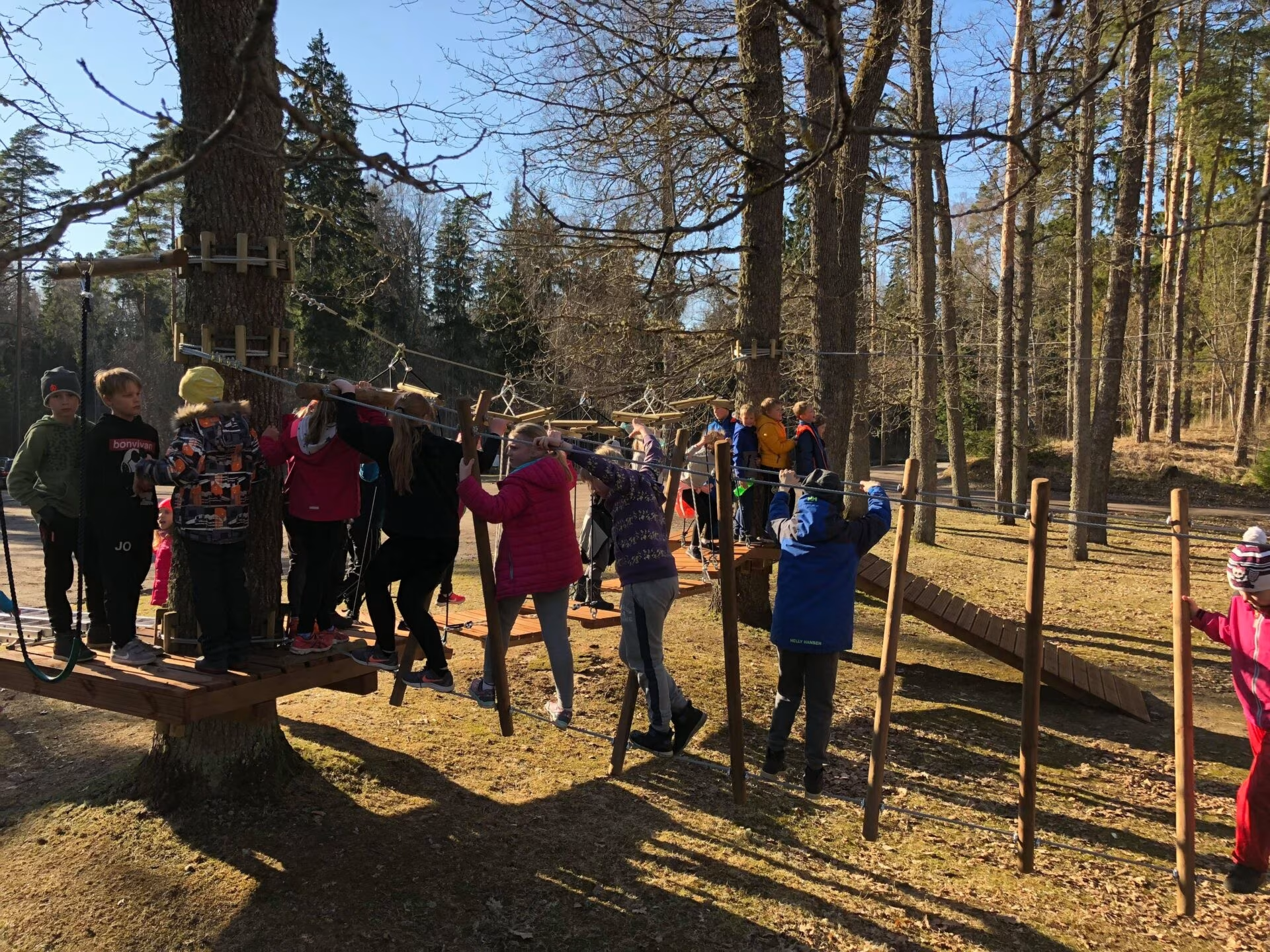
In spring 2018, a low-altitude adventure trail was completed on the territory of the holiday centre. A series of obstacles made of ropes, nets and cables up to 1 m above the ground have been set up between the trees. This includes two zipline descents. Traversing them requires balance, skill and strength.
The adventure trail is a great place to test yourself and get an adrenaline rush, whatever your age. Suitable for both children and adults. Going on the trail is done at one’s own risk. No special safety equipment is used. The trail is free of charge and open 24/7, 365 days a year.
Nelijärve lakes
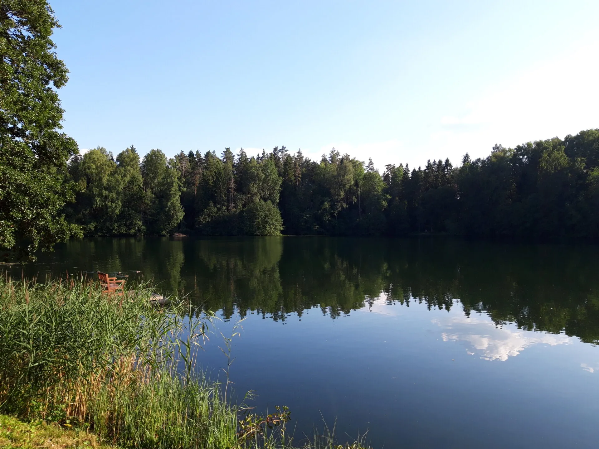
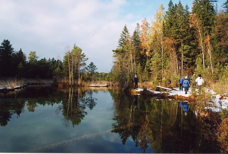
Nestled between the hills adjacent to Nelijärve Holiday Centre, the Nelijärve lakes comprise seven lakes. Nelijärve lakes lie in the northern part of the Kõrvemaa landscape protection area and include Lake Nikerjärv, Lake Vahejärv, Lake Urbukse, Lake Sisaliku, Lake Purgatsi, Lake Ahvenajärv and Lake Linajärv.
Nelijärve Holiday Centre is located just a short distance from Lake Purgatsi. The lake is perfect for swimming, fishing and, in summer, boating and pedalboating. The lake has a sandy beach, piers, a water slide for children and marked swimming areas. Weather permitting, you can skate on the lake ice and plunge into the frozen lake in winter.
Lake area 4.7 ha
length 330 m, width 180 m, average depth 5.3 m, maximum depth 13 m
The name Nelijärve (in English: four lakes) originated from the fact that four lakes were visible at once when looking down from the esker ridge: Lake Urbukse, Lake Sisaliku, Lake Purgatsi and Lake Ahvenajärv.
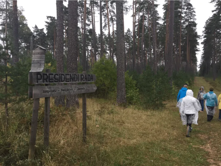
President’s hike
It was the first President of the Republic of Estonia, Konstantin Päts, who proposed the idea of welcoming tourists to Nelijärve. He also played an important role in the development and promotion of the area, as well as in the establishment and advancement of Jäneda Agricultural High School, throughout his presidency.
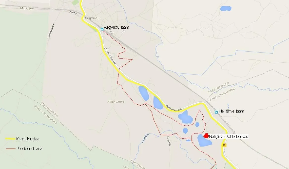
In 1935, boys from the Jäneda Agricultural High School launched a nationwide skiing competition. Later President Arnold Rüütel, an alumnus of the 27th class, studied at the same school and followed the tradition. As such, two of Estonia’s presidents have traversed the paths through these forests, leading to the hiking trail now being known as the “President’s hike”. The President’s hike starts at Aegviidu station, crosses Piibe road at the 37.7 kilometre post, passes the State Forest Management Centre’s Nikerjärve camping area, passes the Nelijärve Holiday Centre and ultimately arrives at Jäneda Manor.
As of 2004, an annual public President’s hike is organised around the time of the Independence Day of Estonia on the Aegviidu – Nelijärve – Jäneda route, usually on skis or, more recently, by Nordic walking. Every year, around 1,500 people have traversed the trail on skis or using walking poles.
Nelijärve Holiday Centre sits in the centre of the 10 km Aegviidu-Nelijärve-Jäneda President’s hike that zigzags between the forests and hills. The trail is marked with blue arrows and signs. Every kilometre ends with a stunning wooden sculpture, whether it’s a bear, a pig or an owl, etc. When starting the hike from Nelijärve en route to Aegviidu, the round-trip distance is 9 km, when heading towards Jäneda, the round-trip distance is 10 km. During winter, provided there is snow, a track groomer is used for classic and skate skiing tracks. Valgehobusemägi is 9.5 km from Nelijärve.
Cycle and pedestrian track
Aegviidu – Nelijärve – Jäneda
The asphalt-covered cycle and pedestrian track along Piibe road runs through Aegviidu – Nelijärve and Jäneda for 12 km.
As the highway twists and turns considerably in this stretch, the cycle and pedestrian track makes for an interesting experience, including small ups and downs. The road is lit in the evenings. The cycle and pedestrian track section from Aegviidu to Kõrvemaa Hiking and Skiing Centre was completed in October 2018. It is 3.5 km from Nelijärve to Jäneda and 8.5 km from Nelijärve to Kõrvemaa Hiking and Skiing Centre.
Aegviidu springs
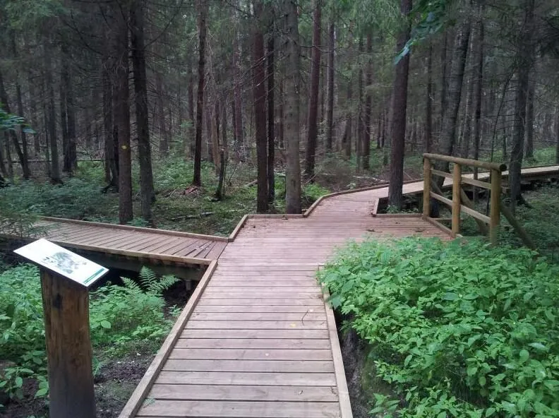
The small raised bog between eskers hides a spring lakelet with more then 20 springs breaking their way to the surface. The shores of the lakelet are floating mats here, hiding springs that are nearly clogged up. In some of the springs, the water is greenish-blue, while others display decayed tree trunks with travertine. A boardwalk leads to the springs. This spring area is known for its primeval nature. A stream flows from the lake into the River Jänijõgi.
It is 2 km from Nelijärve to the springs along a cycle and pedestrian track or a forest trail.
Aegviidu disc golf park
Aegviidu has a disc golf course with 9 holes, suitable for beginners. Located 4 km from the holiday centre. 700 m from Aegviidu railway station. Address: Mäe 2 Aegviidu town Anija rural municipality 74501
A.H. TAMMSAARE MUSEUM at Vargamägi
The museum was opened on 29 January 1978, to honour the centenary of the birth of the writer Anton Hansen Tammsaare. The renovated museum complex featured restored versions of the threshing barn dwelling, cattle shed, dwellings of poor peasants and border fences, all renovated. In addition, hiking trails were constructed in bogs around the farmstead. The museum is 22 km away from Nelijärve (Vetepere village, Albu rural municipality).
The State Forest Management Centre’s Aegviidu-Kõrvemaa recreation area
The State Forest Management Centre’s Aegviidu-Kõrvemaa recreation area stretches from Peterburi highway to Tallinn-Tartu highway. The recreation area lies within the territory of a number of protected areas and features bogs, lakes, swamps, eskers and valleys in addition to forests. It is a great area for outdoor activities in every season. You can go hiking, cycling, skiing, opt for more serious exercise or just go for a stroll. The area presents wonderful opportunities for nature photographers, birdwatchers, wildlife watchers and foragers.
The State Forest Management Centre’s Aegviidu Nature Centre
Aegviidu Nature Centre provides information on recreational opportunities in the area and runs nature education programmes. The Sõõriksoo nature trail starts behind the centre. Address Jaama 7, Aegviidu. The Nature Centre is 3.6 km away from Nelijärve.
The State Forest Management Centre’s Sõõriksoo nature trail
The 1.5 km long Sõõriksoo nature trail starts from Aegviidu Nature Centre, passing through forested areas and the Rehessaare bog. The forested part of the trail (approx. 700) is also accessible for wheelchair users along the designated boarded path. The trail is well-marked and you can manage without a guide. The starting point of the trail is 3.7 km away from Nelijärve.
The State Forest Management Centre’s Nikerjärve campsite
The campsite near Lake Nikerjärv between Aegviidu and Nelijärve is a convenient stopover for hikers and campers on the State Forest Management Centre’s hiking trail.
Nikerjärve campsite is located just 1.5 km away from Nelijärve Holiday Centre, which offers accommodation in 2–3 person rooms, holiday houses or Pääsu Villa rooms as an alternative to camping, as well as catering in the pub, washing facilities in the form of showers, laundry services and various saunas. Lake Purgatsi is ideal for swimming and boating or pedalboating. You can also play billiards, novuss, ping pong, beach volleyball or football, rent bikes and scooters, recharge your batteries and more. In winter, you can go skiing and ice skating if the weather conditions are good. The holiday centre is open 24 hours a day, all year round.
Rehesaare boulder
Rehesaare boulder, also known as the Saunasaare boulder (or Rehessaare Suurkivi, Saunakivi (kivi means rock/stone in English), is a granite boulder under nature protection, located in Kõrvekõla in Tapa rural municipality in Lääne-Viru county, about 400 m east of the border of Mägede village, in the middle of the forest.
Circumference 24.8 or 26 m, length 10.0 m, width 4.9 m and height 5.2 or 6.0 m. The size of the boulder is approx. 170 m3.
According to folklore, this is the boulder Kalevipoeg once threw. Legend has it that once upon a time Saunassaare Siim teased and mocked Kalevipoeg, prompting Kalevipoeg to grab a huge sling stone to throw it at Siimu’s sauna all the way from Aegviidu. However, as he geared up for the throw, he slipped on cow dung and the stone fell onto Suurekivi where it still resides today.
The erratic boulder is 9 km away from Nelijärve.
The State Forest Management Centre’s Uuejärve nature trail
Starts at km 32 of Piibe road, by Uuejärve road.
The meandering trail stretches for 6 km through the varied and interesting terrain of Northern Kõrvemaa. You will witness different types of forest, and landforms and the remains of a Soviet army campgrounds. The starting point of the trail is 10 km away from Nelijärve.
Valgehobusemäe viewing tower
At 107 metres, Valgehobusemägi is the highest peak in Kõrvemaa, located in the village of Mägede in Albu rural municipality. In 1976, a 28-metre viewing tower was erected there, offering a view over Kõrvemaa. Valgehobusemäe Ski and Recreation Centre has been built at the foot of the hill. It is 13 km from Nelijärve to Valgehobusemäe by car or 9.5 when hiking directly through the forest.
Did you know? Once upon a time, Kalevipoeg was ploughing on the edge of the Mägede village with his horse. He then let the horse eat, and lay down to rest. Meanwhile, wolves came out of Röövliorg and Hundiaugu and slaughtered Kalevipoeg’s white horse. A hill formed from the body of the beast, which came to be called Valgehobusemägi (in English: white horse hill). Ridges resembling the legs of a horse run down the hill. The furrows Kalevipoeg ploughed can be found a little further under the forest.
The State Forest Management Centre’s Paukjärve nature trail & observation tower
The circular trail is marked with yellow signs on the trees. There are 9 points of interest on the trail, each having a description, a viewing tower, a campsite on the shores of Lake Paukjärv (please note that the car park is 1 km from the campsite). The 5 km trail takes you through different types of forest, from humid and dusky spruce forests to light-filled pine forests. The starting point of the trail is 21 km away from Nelijärve.
The State Forest Management Centre’s Kakerdaja bog
Kakerdaja bog is one of the largest bogs in South Kõrvemaa. It covers approx. 1,000 hectares. The picturesque bog with its many bog pools is famous for being two-tiered, meaning that it has a belt of bog pools on two different levels. Thousands of aquatic birds stop over here during their spring and autumn migrations. Lake Kakerdaja lies in the middle of the bog. The State Forest Management Centre’s nature trail runs through Kakerdaja bog, past Noku campfire site, and circles around Lake Väike Kalajärv and Lake Suur Kalajärv before returning to the Noku campfire site. The nature trail through Kakerdaja bog is 8 km long, 3.3 km of which is boarded. The starting point of the bog is 18 km away from Nelijärve.
Aegviidu Station Anno 1870
Aegviidu, located in the heart of Kõrvemaa, began to develop in the 17th century around a post station built on the Tallinn – Tartu road. Aegwiidu Jaam Anno 1870 MTÜ (NGO Aegviidu Station Anno 1870) manages and develops the station building, water tower and sauna in Aegviidu. The station building and sauna are open to guests.
Aegviidu low-altitude adventure park
A low-altitude adventure park was opened in Aegviidu in January 2011. The LEADER-funded adventure park offers year-round outdoor fun for young and old alike. A skateboard ramp and a bandstand are located in the immediate vicinity of the adventure park. Address: Basseini 4, Aegviidu. Aegviidu is 4 km away from Nelijärve.
Many sports and recreation centres are concentrated in Kõrvemaa: Nelijärve Holiday Centre, Sportland Kõrvemaa Hiking and Skiing Centre, Aegviidu Recreation Centre, Jäneda Tourism and Musta Täku Stables, Valgehobusemäe Ski and Recreation Centre, Kivisaare Riding Farm.
Jäneda’s handicraft and farm fairs, various dances and the Aegviidu – Nelijärve – Jäneda 10 km hiking trail known as the President’s hike are also popular.
Piibe road – INTEGRATED TOURISM ROAD
Piibe road – the Facebook page is the best way to keep up to date with all the events along the road.
For centuries, Piibe road has connected two of Estonia’s largest cities, Tartu and Tallinn. It was the road people took to go to fairs, church and the tavern, the road that led to riches and heavenly bliss as well as the odd ambush by highwaymen and rogues. This road has seen kings and soldiers, war and peace. It is also the road that many young people follow in seek of knowledge. At one time or another, you might have run into E. Lönnro, A.H.Tammsaare, K.E. v. Baer, Ed.Vild, G.H.Wells, O.Luts, A.Rüütel and many other intellectuals important to Estonia and the world.
Given the fast pace of life today, it is both healthy and invigorating to take a break and drive from Tallinn to Tartu, or vice versa, along the historic Piibe road, where the speed limit may be lower, but the landscape is exceptionally varied and route is packed with monuments providing a cross-section of Estonian culture and history.
Järva-Jaani Firefighting Museum and Vintage Technology Sanctuary
The Järva-Jaani Firefighting Museum, built on the foundations of the former rectory manor stables, was opened in 1999. Museum exhibits include an old firefighting union flag that had been missing for 44 years, a new jubilee flag, photos, medals and diplomas.
The Vintage Technology Sanctuary is a part of the Järva-Jaani Firefighting Association. The museum was set up to collect vehicles that once travelled on our roads during the Soviet period, manufactured in the factories of the former Soviet Union and other countries, as well as former agricultural and road machinery and all manner of fire-fighting equipment. At the moment, the focus is on collecting and exhibiting surviving vintage machinery, this means that new acquisitions are displayed in the state they arrived in. However, some exhibits have also been fixed as far as possible. To date, the sanctuary has collected more than 300 machines in various states of repair.
The exhibits include cars, buses, trucks, tractors, as well as a road grader, several combine harvesters, a welding aggregate and an ice drill.
Address Lai tn 7 Järva-Jaani. Järva-Jaani is 31 km away from Nelijärve.
Jäneda manor
For many years, Jäneda manor has been the heart of Jäneda village. The last manor house was built by Johan von Benckendorf between 1913 and 1915. The best overview of Jäneda’s history can be found at the Jäneda Manor Museum. It is also an important place in the history of Estonia’s first agricultural high school, as a large number of Estonian politicians and agricultural scientists studied in Jäneda. The President of the Republic of Estonia, Mr. Arnold Rüütel, was also an alumnus of Jäneda. Jäneda Manor is 4 km away from Nelijärve.
Aravete karting circuit
20 km from Nelijärve is Aravete karting circuit, the largest and best karting circuit in Estonia and the Baltics. The asphalt circuit is 1,001 metres long. It is used for kart and supermoto races, that can be very exciting for spectators.
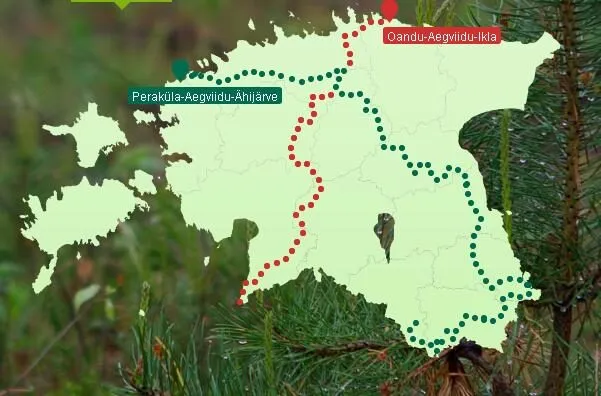
The State Forest Management Centre’s 375 km hiking trail Oandu – Ikla
Source: www.loodusegakoos.ee
Oandu-Ikla hiking trail
The State Forest Management Centre’s hiking trail is the first hiking trail that crosses the whole of Estonia. The 375-km route starts in Lahemaa National Park in Northern Estonia, winds through the deep forests of Kõrvemaa and one of Europe’s most spectacular mire landscapes – Soomaa National Park. The hiking trail then leads through the forests of Pärnu county until it winds its way to the seaside villages and beautiful beaches of the Gulf of Riga. The State Forest Management Centre’s hiking trail crosses 6 counties, 2 national parks and 9 protected areas, and ends at the Estonian-Latvian border point in Ikla. The trail is marked with kilometre posts, coloured markings and signposts to help you stay on track. Educational panels along the trail provide insights into forest management and heritage, culture and recreation.
Three good reasons to hike on the State Forest Management Centre’s hiking trails.
It is the longest hiking trail through Estonia and brand new – keen hikers will certainly find it worth a visit. Even if you are not much of a hiker, it will be worth your while just for the thrill of exploration. And if you do not fall into either of these categories, it still makes for a great opportunity to learn about the diversity of the forest.
Section II of the hiking trail Kalmeoja – Nikerjärve (38 km)
After traversing Viru bog, hikers have to cross Tallinn-Narva highway. From here, the second section of the trail starts, which first takes you to the Northern Kõrvemaa nature reserve. The shortest way to describe this section is “good old Kõrvemaa”. It starts with the Northern Kõrvemaa nature reserve, which has a wide variety of nature trails, campsites and campfire sires. This is followed by Kõrvemaa protection area, which does not have quite as many protected nature sites, but is still beautiful and interesting.
More specifically, the first part of the hiking trail, or 32 kilometres, is a classic hiking trail through Northern Kõrvemaa all the way to Aegviidu town. The hiking trail also partly overlaps with the Kõrvemaa jogging trail. From there, it is 39 kilometres of alternating hiking trails and gravel roads through Kõrvemaa to Paunküla reservoir. From there, the trail follows mostly different roads until the county border. The largest populated sites that the hiking trail passes through or is in the immediate vicinity of on this section are Aegviidu, Ardu, Paunküla and Kõue.
The official campgrounds along the hiking trail in this area are the Järvi Pikkjärve campsite, the Paukjärve campsite, the Jussi campsite, the Nikerjärve campsite, the Mägede campfire sites, the Noku campfire site, the Napu campfire site, the Hiieveski car park campfire site.
Nikerjärve campsite is located just 1.5 km away from Nelijärve Holiday Centre, which offers accommodation in 2–5 person rooms as an alternative to camping, as well as catering in the pub, washing facilities in the form of showers and baths, and various saunas. Lake Purgatsi is ideal for swimming and boating or pedalboating. You can also play billiards, novuss, ping pong, beach volleyball or football, rent bikes and scooters, recharge your batteries and more. There is even an option to store your extra equipment to make the rest of your journey more enjoyable. The holiday centre is open 24 hours a day, all year round.
Kõrvemaa’s nature deserves a special mention, especially Lake Paukjärv, Jussi lakes, Jussi heath, Valgehobusemäe, Noku farm, Kakerdaja bog and from there Paunküla reservoir and Paunküla hills.
Section III of the hiking trail Nikerjärve – Hirvelaane (65 km)
Section III of the hiking trail passes through the Kõrvemaa landscape protection area, which does not have quite as many protected nature sites as the previous section, but is still beautiful and interesting. The route also includes one of the longest boardwalks in Estonia. It runs over 3.5 km across Kakerdaja bog. After making your way out of Kakerdaja bog, it is 17 kilometres of alternating hiking trails and gravel roads through Kõrvemaa to Paunküla reservoir. After Paunküla reservoir you have to cross Tallinn-Tartu highway and from there the hiking trail mainly follows different roads all the way to Rapla county.
The largest populated sites in the vicinity of section III of the hiking trail are Ardu, Paunküla and Kõue.
The official campgrounds along the hiking trail in Kõrvemaa landscape protection area are the Nikerjärve campsite, the Mägede campfire sites, the Kalajärve campfire site, the Noku campfire site, the Napu campfire site and the Hiieveski car park campfire site.
Nikerjärve campsite is located just 1.5 km away from Nelijärve Holiday Centre, which offers accommodation in 2–5 person rooms as an alternative to camping, as well as catering in the pub, washing facilities in the form of showers and baths, and various saunas. Lake Purgatsi is ideal for swimming and boating or pedalboating. You can also play billiards, novuss, ping pong, beach volleyball or football, rent bikes and scooters, recharge your batteries and more. There is even an option to store your extra equipment to make the rest of your journey more enjoyable. The holiday centre is open 24 hours a day, all year round.
Valgehobusemäe, Noku farmstead and Kakerdaja bog, followed by Paunküla reservoir and Paunküla hills are some of they key sights along the way.
The hiking trail officially ends in Ikla, a village on the Estonian-Latvian border.
After several weeks on the road, stopping and celebrating the end can seem too abrupt. If you feel like pushing even further, we recommend visiting Ainaži. One of the attractions of this border town, known by the name of Heinaste for Estonians, is the maritime school museum, the lighthouses and the breakwall.
We hope you enjoy hiking on the State Forest Management Centre’s hiking trails!
The State Forest Management Centre’s 820 km hiking trail
PERAKÜLA–
AEGVIIDU–
ÄHIJÄRVE
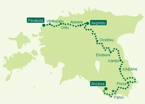
In 2013, a new branching route was added to the existing Oandu-Aegviidu-Ikla trail, which ran from Aegviidu to Ähijärve. The new branch followed the same principle as the first, linking existing trails and stops into a single road. This branch became somewhat longer – it initially covered a total of 628 kilometres. in 2015, another section was added to the above branch – the 192 km long road from Peraküla to Aegviidu, which together with the Aegviidu-Ahijärve section now form the State Forest Management Centre’s Peraküla-Aegviidu-Ahijärve hiking trail.
The State Forest Management Centre’s Peraküla-Aegviidu-Ähijärve hiking trail crosses nine counties, a number of protected areas and exhibits many wonderful landscapes of Estonia along its 820 kilometres – the beautiful sand and pebble beaches of Lääne county, the deep dark woods of Harju county, the beautiful grain fields in Estonia’s bread basket in Järva county, the impressive wetlands in Endla bog and Emajõe Suursoo bog, the hilly and light pine forests of Põlva county and the local natural wonders of Võru county.
The trail is marked in nature with white-green-white colour markings and signposts.
Section IV Alavere-Aegviidu (32 km) –
On this section, the hiking trail enters the forests of Kõrvemaa. In Alavere, there is a shop along the way where you can replenish your rations. The River Jägala and the River Jänijõgi are also on the way. This section ends in Aegviidu Nature Centre.
Aegviidu Nature Centre is located just 3.5 km away from Nelijärve Holiday Centre, which offers accommodation in 2–5 person rooms as an alternative to camping, as well as catering in the pub, washing facilities in the form of showers, and various saunas. Lake Purgatsi is ideal for swimming and boating or pedalboating. You can also play billiards, novuss, ping pong, beach volleyball or football, rent bikes and scooters. The holiday centre is open 24 hours a day, all year round.
Section V Aegviidu-Oostriku (107 km) –
This section of the hiking trail starts from the yard of the Aegviidu Nature Centre and overlaps with the Oandu-Ikla hiking trail for the first 30 kilometres.
Nikerjärve campsite is located just 1.5 km away from Nelijärve Holiday Centre, which offers accommodation in 2–5 person rooms as an alternative to camping, as well as catering in the pub, washing facilities in the form of showers, and various saunas. Lake Purgatsi is ideal for swimming and boating or pedalboating. You can also play billiards, novuss, ping pong, beach volleyball or football, rent bikes and scooters. The holiday centre is open 24 hours a day, all year round.
As you ascend Matsimäe esker, the trail forks at the Rabav hiking lodge where the trail towards Ähijärve turns directly south. The trail crosses Seli bog, heading to Simisalu and Vargamägi and from there towards Järva-Madise across Kodru bog. The nature trail sort of runs out here for a while because it largely takes you across Järve county on roads lined with fields and meadows. The larger settlements along the trail include Järva-Madise, Aravete, Järva-Jaani and Koeru, where you can stock up on supplies, enjoy civilisation or even choose to start or finish your journey. You pass through Koeru along the main road and head towards the Norwegian springs as you leave the settlement. From there, a gravel road takes you to the western part of Endla nature reserve.
Kõrvemaa landscape protection area
Situated between Harju plateau and Pandivere uplands, Kõrvemaa lacks clear boundaries: locals tend to describe it in one way and official publications in another. The easiest way to put it is probably this: Kõrvemaa runs northeast to southwest from the edge of the Gulf of Finland to the River Navesti.
Known as the Switzerland of Estonia, Kõrvemaa is an exceptionally diverse region. Covering a total area of 3,130 square kilometres, it includes rare karst areas: rivers flow both underground and above ground, and during drier periods the caves make fascinating places to explore.
Above all, however, Kõrvemaa is famed for its large bogs and hilly kames and eskers. According to legend, Kalevipoeg took a rest here from ploughing only to have wolves show up and slaughter his white horse. The body of his horse is said to have become the highest point in Kõrvemaa, i.e. Valgehobusemägi at 107 metres above sea level, and his unfinished furrows are the reason for the uneven landscape of the area. Today, the magnificent view from Valgehobusemägi is enhanced by a 28-metre-high viewing tower open to the public.
The State Forest Management Centre’s excellent hiking trails in Harju county: Sõõriksoo nature trail, Kakerdaja bog, Uuejärve nature trail and Paukjärve nature trail.
The area is rich in protected plants (23 species of orchids have been found here in recent years). Kõrvemaa is also an important nesting site for a number of rare bird species such as the golden eagle, the lesser spotted eagle and the black stork. In springtime, the courting of the wood grouse in quiet forest clearings also provide great photo and birdwatching moments.
The name Kõrvemaa can be a misleading for many. The literal meaning of the name suggests an arid and barren landscape, but the region actually boasts more than 100 lakes, both wild and managed, and two large reservoirs: Soodla and Paunküla. The River Valgejõgi, with its bends, beaver dams and small rapids, is particularly popular among canoe and kayak enthusiasts. Pine forests are prevalent in Kõrvemaa, followed by birch and fir forests. There are excellent hiking trails in the forest in Harju county. The forest is the green gold of Kõrvemaa.
Autumn is the best time to come to Kõrvemaa or a photo shoot: even if you fail to get a snap of a lynx, a bear or an eagle, the colourful bogs and forests will ensure a memorable experience. Its varied landscapes make Kõrvemaa the perfect destination for all nature lovers.


